AGIS’ C5ISR Software Assists U.S. Stealth mode Operations

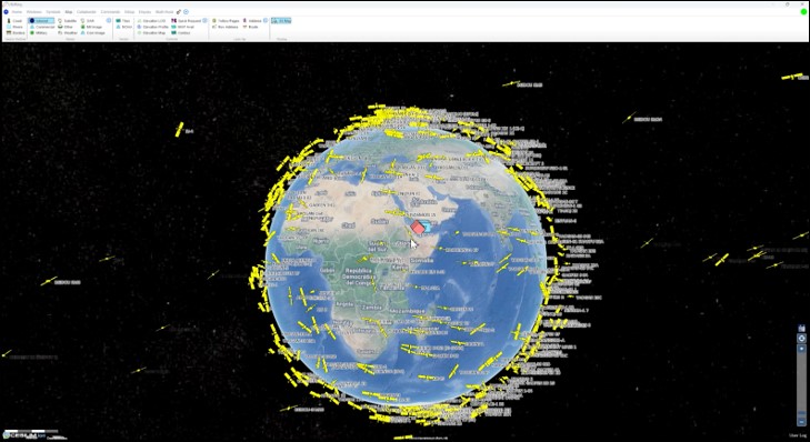
Visualization of curently orbiting satellites
How satellite owner identification enhances defense capabilities
JUPITER, FL, UNITED STATES, December 16, 2024 /EINPresswire.com/ -- Satellites, UAV’s, and Long Range missiles have changed the nature of warfare for both offensive and defensive operations. In today’s warfare tempo, a soldier’s survival often hinges upon the ability to remain unseen and undetected amid relentless surveillance of overhead satellites and drones. The phrase "to be seen is to die" captures the essence of stealth and the importance of remaining undetected in military operations because high stakes are involved in combat situations where visibility can mean threats to survivability.
Modern satellites possess capabilities that allow the capture of high-resolution images, the detection of heat and communication signatures. These allow the monitoring of troop movements with unprecedented precision. Since satellite and UAVs can relay intelligence rapidly, even a moment of exposure can lead to devastating consequences from airstrikes and long-range fires,
Being careful to remember that to be seen is to die, warfighters soon understand that concealment is an essential skill — one that determines life or death, and success or failure. Understanding the importance of strategy, deception, and the element of surprise in military operations, AGIS has jumped in by building a capability for ground troops to identify enemy satellites and drones in real time, and AGIS has integrated this capability into its COP software.
Within its CJADC2 C5ISR system, the AGIS COP assists in shielding soldiers from overhead observation by providing information on a satellite’s location and a satellite’s country of ownership. The AGIS C5ISR software can inform soldiers if and when a hostile country’s satellites are passing or about to pass over their ship and ground positions. AGIS provides real time tracking done with software tools that use the specific orbit to predict when and where a satellite owned by a hostile country will be visible from any given location on Earth, and thus the dates, times, and directions for each of their satellites' passes. This early warning of possible surveillance or discovery will enable our forces to take necessary precautions, such as altering positions, avoiding GPS use, or modifying communications to avoid detection. Being seen or detected can lead to failure, while stealth and making unexpected maneuvers can lead to victory.
AGIS provides this capability as military operations become increasingly reliant on space-based assets and the importance of accurate, real-time detection, identifications, and visualizations continue to grow, making this software feature an essential component for future military readiness.
See www.agisinc.com/videos/LifeRingOverview.mp4
For information on this system, contact Cap Beyer at beyerm@agisinc.com or at 561-744-3213.
To get the latest version of any of our Thick client apps, go to www.agisinc.com/download
To try our Web client system, go to either www.liferingmilitary.com _or www.liferingfirstresponder.com
Made in the USA by American Citizens
Malcolm K. Beyer, Jr.
Advanced Ground Information Systems (AGIS), Inc.
+1 561-744-3213
beyerm@agisinc.com
Visit us on social media:
LinkedIn
AGIS Visualization of Orbiting Satellites
Distribution channels: Aviation & Aerospace Industry, Military Industry, Politics, Technology, World & Regional
Legal Disclaimer:
EIN Presswire provides this news content "as is" without warranty of any kind. We do not accept any responsibility or liability for the accuracy, content, images, videos, licenses, completeness, legality, or reliability of the information contained in this article. If you have any complaints or copyright issues related to this article, kindly contact the author above.
Submit your press release